Question-and-Answer Resource for the Building Energy Modeling Community
Get started with the Help page
Ask Your Question
1

Solar Irradiance [TMY vs Actual data]

asked 2021-09-14 17:32:04 -0500

Aly ElHefny's avatar

updated 2022-02-07 14:25:07 -0500

Hello everyone, I hope you are in good health.

The following plot presents the global horizontal solar radiation from the TMY file for a specific location compared to the actual measured global horizontal solar radiation for the same station. I expected that the averaged irradiance trajectory from the TMY file will correspond to the measured data of the same year. But even the peak is significantly shifted.

image description

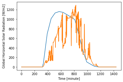
What is the best way to approximately predict the hourly averaged global horizontal solar radiation trajectory for a future day ?

edit retag flag offensive close merge delete

1 Answer

Sort by ยป oldest newest most voted
0

answered 2021-09-23 08:28:27 -0500

Debayan93's avatar

Hi Aly,

It is better to plot a 'sunny day' (less cloud interference) to compare the actual vs TMY or a few continuous days. This shift could be possible due to two reasons:

1) Locations are slightly different

2) Local interference during the measurement period while TMY averages it out over the year.

Meteonorm is a commercial source for availing future climate data. There could be other services available depending on the region.

edit flag offensive delete link more

Comments

Hey Debayan, For the location, I'm using the exact station location for the both cases. I understand that TMY presents averaging values but I expected (or hoped) the average would at least have a peak close to the actual one rather than that shift. I know of a number of payed services available which include meteonorm for predicting the solar irradiance but I'm more interested in opensource with sub-hourly increment if available.

Aly ElHefny's avatar Aly ElHefny  ( 2021-09-23 08:37:23 -0500 )edit

For the comparison, I suggest then use a different source of TMY data (ex: PVGIS). Alternatively, you can utilize PVLIB package implemented in Python to simulate GHI on your station location to compare against measurement data.

Debayan93's avatar Debayan93  ( 2021-09-23 08:41:44 -0500 )edit

Your Answer

Please start posting anonymously - your entry will be published after you log in or create a new account.

Add Answer

Training Workshops

Careers

Question Tools

1 follower

Stats

Asked: 2021-09-14 17:32:04 -0500

Seen: 196 times

Last updated: Sep 23 '21